Cael & Dad's Appalachian Trail Hike - Georgia July 2017
Hiking a section of the AT has been something I have had interest in over the last couple years. I have been reading blogs, slowly compiling gear, and learning more about the trail and its history. This July having some extra vacation from my time in Texas last year for work and a long July 4th weekend, Cael and I were able to go tackle a 61.7 mile section in Georgia. It was a memorable experience full of laughs, lessons, and a few tears along the journey.
We have done a variety of day hikes as a family in the Appalachian mountains but strapping a 30+ lb. pack loaded with water and several days food has a way of humbling your mileage estimates. Our trip was originally planned for just shy of 80 miles over 7 days. On Day 2 & 3 Cael and I began to realize it was achievable, but would make for a couple of miserable days including a 15.4 mile day. We got out the maps and decided to get off 1 day earlier and shorten the trip by 17 miles.
It was the right choice to shorten our trip and we learned it's not about the destination but rather the journey! Always remember when adventuring with kids and even for yourself, if the trip becomes a chore and miserable, you may loose all sense of going back again. Let our journey begin!!
Day 0 - Drive to Georgia and Amicalola Falls hike (July 1, 2017)
Mileage - 1.2 miles
Amicalola Falls Visitor's Center to top of falls via AT Approach Trail
We had spent the week preparing our packs and making sure we had every item on the list. Saturday morning July 1st we loaded the car and left home by 8:00 am bound for Georgia! We had planned for a leisurely day of travel with some stops along the way, a hike on the Approach Trail as a family, and a nights stay at the beautiful
Amicalola Falls Lodge.
We quickly made our way 3-1/2 hours down the road and stopped in Dahlonega, GA just a ways from Springer Mountain and the AT. Cael and Hazel have both been very interested in rocks and gems for over a year now. We decided a great stop would be
Crisson's Gold Mine which operated as commercial gold mine from 1847-1982 and was home to the United States first gold rush. For a small admission price, everyone gets a pan of sand to hunt for gold and a bucket of sand and gems. We were all excited to try gold panning and learn what a hard job it really is. After the gold and gems were collected, we headed into town to the Moon Cafe for a wonderful brunch and drinks. Dahlonega is beautiful little mountain town and we definitely recommend a stop here.
 |
| Flakes of gold! |
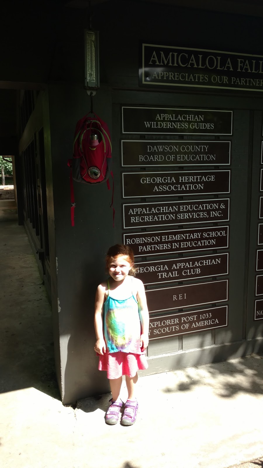
Upon arriving to Amicalola Falls State Park we made our way to the Visitor's Center located at the start of the Appalachian Trail Approach Trail. They have neat exhibits with real snakes and turtles and a history of the AT. Cael and I visited with a Park Ranger to sign in with our itinerary as official section hikers! It was then time to weigh our packs outside the ranger station and the very famous scale used by many thru and section hikers of the AT. Cael's pack weighed 14 lbs and mine 29 lbs without water. Hazel had to weigh her back which came in at 3 lbs including a half full bottle of water. We were all proud to take our picture with our packs and claim ourselves ready for an AT hike!
We made our way to the lodge and got checked into our room which was a beautiful loft room on the top floor overlooking the Appalachian Mountains.
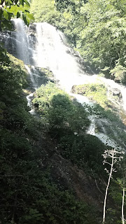
It was now time to start with a small AT hike on the Approach Trail to the top of Amicalola Falls. It is a highly visited area and is very accessible. We left the Visitor's Center under the arch and took the 604 stairs to the top of the Falls. This hike is not easy and is a very steep climb. It took us about 1-1/2 hours to hike up while enjoying the view along the way. On the way down we took the Ridge Trail but a 1/2 mile from the car a thunderstorm blew in with high winds and rain, we ran most of the way back but still got drenched by the parking lot.
After our enjoyable hike as a family, we spent the evening at the Lodge on the patio and ate a big meal in the restaurant. That evening it started to hit me that Cael and I were heading into the mountains for a week. I had confidence we had packed all our gear and knew what to expect but I still went to bed uneasy that evening.
 |
| Cael stands outside the lodge looking to the Mountains, I wonder what his thoughts were the eve before our hike. |
Day 1 - Amicalola Falls Lodge to Stover Creek Shelter Mile 2.8 (July 2, 2017)
Mileage - 10.4 miles
Total Trip - 11.6 miles
Today was truly the start of our trip and time on the trail. Cael, Hazel, and I went to the restaurant for one last meal in civilization and I enjoyed a few cups of hot coffee. We made our way to the trail and said our goodbyes. Hazel and Anne were going to walk the 1 mile trail around the lodge that morning before heading home. Cael and I took off on the Approach Trail by 8:00 am. We hiked in the thick morning humidity as the sun broke through the trees and lit the trail for us. At around mile 2.5 we passed a stealth campsite with a young couple just waking up. About a 1/2 mile later that same man caught up to us and asked for help with his map location. They had gotten in late last night and walked by headlamp to their current campsite. He had thought they were almost to a point located at mile 7.6, I had to break the news they were only 3 miles in. He seemed discouraged and like the trail was already more than he expected.
 |
| Springer Mountain just a few short miles ahead! |
The Approach Trail is no joke and is a tough climb to Springer Mountain (the official Southern Terminus of the Appalachian Trail). Many hikers skip this section while others see it as a special part of their hike. In July, the trail is fully hid within the trees and offers no views. We enjoyed the Approach Trail but I have no ambition to ever hike it again. Frosty Mountain is a perfect example where you climb to over 3,400 feet just to reach a peak completely covered in trees. Around mile 5 we met a couple out of breath who said they just passed a sleeping copperhead in the trail. The couple had placed a bent stick in the ground about 70 yards back near the snake. Cael and I proceeded cautiously watching for the snake as we passed the stick. We never did see it as it must have awoken and gone in the woods. About a mile after the snake location we met a lady who said a bear had crossed the trail earlier. Although we never saw the bear or the snake we learned the best animal encounters are those you are warned about.
The last mile to Springer Mountain is a tough climb up and by that point we were done mentally with the Approach Trail. When we finally did crest the top we gained the view we had been looking for. We met another couple up there from Atlanta just out on a day hike. They took our picture and we signed the register. A swarm of honeybees flew around us and our packs in the sun so we hiked on to Springer Mountain Shelter for a lunch break of tortillas with cheese and beef sticks. I wanted to unload the most perishable and heaviest items from the food pack. Unfortunately the bees had also come to lunch so we kept the break short and hiked on knowing we had just over 2.5 miles to our shelter for the evening.
 |
| Modern plaque showing Southern Terminus of AT |
 |
| Cael enjoys the view from Springer Mountain |
 |
| Springer Mountain register signing |
 |
| The first official white blaze and original AT plaque |
 |
| Springer Mountain Shelter for lunch |
The hike down from Springer Mountain going north follows a 1 mile section of the AT towards a parking lot popular with day hikers. Being the Sunday of a Holiday weekend, we met over 50 hikers in that 1.0 mile section. We knew it would be busy on a Holiday weekend but this was just making the hike slow as we paused for dogs, kids, and even adults in flip-flops slipping on the rocks and mud. We cruised past the parking lot filled with cars and people and the trail immediately got quiet for us. Cael had started to get tired legs at this point but we made it to the Stover Creek Shelter at 3:30 pm. We met a man from Austria who had stopped for a coffee break, he was section hiking the AT over a 4 year period. He had done the northern half the last two years and was hoping to get to the Shenandoah's this year and then finish next Summer.
Stover Creek Shelter is a newer one built in 2006 and has a loft so it can hold up to 14 hikers. We swept out the top and bottom floors since we were the first ones in that afternoon and setup our sleeping pads and quilts on the lower floor. Shortly after setup we met Sam from Birmingham, AL. She is a 24 yr old teacher who was on her first hike of the AT and had started from Springer Mountain earlier in the day, it was nice to also meet another AT newbie. Mary from New Orleans arrived later and was on her last evening on the trail. She had started North at Dick's Creek Gap and would finish at Springer Mountain in the morning. Cael and I went to the creek down the hill and filtered water, it was nice and cold. We also washed up in the creek and cooled down from the humid hike that had temps almost near 85.
 |
| Stover Creek Shelter |
 |
| Bearbox for food, due to increased bear activity these were found at all the shelters south of Neels Gap |
 |
| Creek nearby for water and washing up |
Our first meal at the shelter that night was Mountain House beef stroganoff. It was good but neither one of us were really that hungry. They say it takes over a week before a hiker's appetite really kicks in, until that point fluids are the only craving.
We had finished up supper when Bailey and her Dad from Sarasota, FL arrived to the shelter. They were also on their last evening on trail having started at Dick's Creek Gap. Bailey is going into her senior year of high school and enjoys hiking with her Dad. They had a great sense of humor and Bailey is hoping to thru-hike the trail someday. We traded stories with them and Mary to get some tips on what lies ahead. They told us about the tough climbs and where to find good shelters and water. We were in our quilts by 7:00 pm and asleep by 8:00. After the long day of hiking we were tired and fell asleep fast but struggled to get a good night's sleep that first night.
Day 2 - Stover Creek Shelter to Gooch Mountain Shelter Mile 15.8 (July 3, 2017)
Mileage - 13.0 miles
Total Trip - 24.6 miles
Cael and I both were up before 6:00 am excited to be waking on the Appalachian Trail and our week ahead. We hadn't slept well and the temps never really cooled off much overnight. It was very humid at the lower elevation and fog filled the air. We packed up camp, ate a pop-tart, and made our way down the trail. We had planned to hike the less than 3 miles to Long Creek Falls and stop for breakfast. It was a short 0.25 mile blue blaze (side trail) off the AT and was roaring with water from all the rain. After a water break and bagel topped with Nutella Hazelnut spread we continued on. For the first 4 miles of the day the trail followed the creek, the campsites along it were all packed with people out enjoying the long weekend.
 |
| Long Creek Falls |
It was a sunny and warm day, yes we realized it was July in Georgia, but it took a toll on us today. The last 9 miles to the shelter was filled with lots of big climbs. Hawk Mountain was the first one to tackle and put us over 3200'. We stopped for a longer break near Hawk Mountain Shelter with snacks and water. I could tell the hopeful 13 mile day was already wearing on Cael. His ankle had started to bother him with pain and the humidity was making for a tough hike. At this point, I felt that we would need to find an alternate plan to camp short of Gooch Mountain Shelter. We descended Hawk Mountain to Hightower Gap that crosses a road. After crossing the road we found two different trails neither of which were marked. We decided to stay here for a bit hoping to see another hiker who might lead us in the correct direction. 4 hikers then came down from Hawk Mountain and were getting picked up by a shuttle there to end their 3-day hike. They were unfamiliar with the area but one of them was kind enough to walk down one of the trails trying to find a white blaze and would report back. He went a 0.25 mile up one trail until he found an AT sign and came back. By this time Sam from Birmingham who was at the shelter with us the night before had caught us. Luckily the long break and seeing a familiar face gave Cael a new hope on the day.
Between Hightower Gap and Horse Gap is a very long section of steep up and downs which we called the roller coaster. We took a snack and water break at Horse Gap while Sam passed us onto the next climb. Sassafrass Mountain was probably the toughest climb of our hike and we hit it mid-afternoon in the heat. It is a 700' climb over a 1.0 mile distance. It took multiple breaks to get up the mountain and was like playing hiker leap frog. We would pass some hikers, then they would pass us, and vice versa all the way up. One set of hikers we met on the way up was Sam from Michigan and Michael from Daytona Beach, FL. We talked about the climb and the next water source available which was not until after Justus Mountain. The big climbs and humidity had us all short on water by this point.
Cael felt accomplished after tackling Sassafrass so we tore up Justus Mountain. At this point we dealt with some passing rain showers and a slippery descent to Justus Creek. By the time we got to the creek we were spent physically. We filtered fresh cold water and swam in the creek. It felt so good to just kick off the shoes and shirt and soak in cold water. We then cruised the last mile and a half to Gooch Mountain Shelter for the evening arriving about 4:30 pm.
The shelter was full with a couple of families and several hammocks and tents were already set-up. Cael and I introduced ourselves then setup our hammocks on a nice spot near the shelter. We filtered water, did chores, and prepared supper. I had picked up a dehydrated meal of Cheddar Wild Rice soup while in Grand Marais, MN. They are made by Camp Chow in Grand Marais and offer many vegan, low-sodium, and cold prep meals. I will definitely be getting more of these for future backpacking trips.
Around 7:00 pm we were just getting ready to hit the hammocks and relax for the evening when a heavy rain shower moved in. It was nice that everyone came to the shelter and we had a trail social event that evening. We met a couple of great families from Tennessee and Georgia. The Georgia family had hiked this area many times in their lives and were full of tips and tricks. They taught Cael how to play the card game speed. Their younger boy Will and Cael had some heated battles with Speed and Go Fish that evening. We played by lantern until after 9:00 pm when it was certainly past bed time and we all retired for the night.
I somehow mistakenly deleted the set of photos I had from this afternoon and evening at the shelter, trail oops.
 |
| Hiking in the rain coming down Justus Mountain |
 |
| A much needed swim at Justus Creek |
Day 3 - Gooch Mountain Shelter to Woods Hole Shelter Mile 28.1 (July 4, 2017)
Mileage - 12.3 miles
Total Trip - 36.9 miles
Completing all the big climbs yesterday gave us a sense of accomplishment but also a feeling that we did not want to do big mileage days everyday of our trip. Cael and I looked at various maps and options and decided we would either extend the trip by 1 day to Sunday evening to hit Dick's Creek Gap or end 1 day earlier on Friday at Unicoi Gap. In the end we decided to end Friday at Unicoi Gap and go home to relax that weekend with Anne and Hazel. We promised we would come back in the near future to finish this section and reach our goal.
Even with shortening our trip we still had a tough 12.3 mile day ahead of us. We were up at 5:45 am packing up camp and eating our daily pop-tart. We talked with the two families at the shelter until about 7:00 am and hiked out with them. Will was having a hard time on the hike and had decided to leave the trail at Woody Gap five miles from the shelter. They were helping Will get going that morning so Cael and I took off ahead. Cael was feeling down that morning about the long miles ahead and his legs getting tired. Just as I was looking for ways to cheer him up we ran across a large field of blackberries. Cael and I enjoyed a nice handful of ripe blackberries and continued on. We had some nice views before Woody Gap and enjoyed breakfast on a nice overlook on Ramrock Mountain. As we headed down Ramrock we found a batch of ripe blueberries which were amazing. We were thankful to enjoy them before the birds or bear got them. The AT crosses Woody Gap along Highway 60 in Georgia and is a popular roadside rest area for travelers and day hikers. Being the 4th of July we found a full parking lot and crowds out with cameras. It was nice to see so many families out enjoying America's trails.
We left Woody Gap for the steep climb to Big Cedar Mountain. At first we were passing day hikers but Cael's legs got tired near the top and he seemed down. I took a break and told him we were almost to the top but he broke out in tears. The tough miles had accumulated to this moment. As with the whole trip, I told Cael we could end our journey at any time and go home, I wouldn't be mad and would be proud of what we had already accomplished. I asked him in this moment if he wanted to continue up the Mountain and see the view or head back to Woody Gap and call Mom. He fought off the tears and said he wanted to go on. We were both rewarded with an amazing view on top of the mountain. A couple day hikers took our picture and we enjoyed a long snack and water break.
 |
| Big Cedar Mountain |
 |
| A downed tree from last night's storms |
That afternoon was alot of downhill and easy hiking. Cael's spirt improved and we got an afternoon rain shower which cooled things down. We made it to Wood's Hole Shelter by 3:30 and were the first ones to arrive. The shelter is a beautiful small log shelter built in 1998 that holds 7 hikers. It is 0.4 miles off the trail but worth it. I filtered water for us and hung out our hammocks to dry from the rains at Gooch Mountain. Another hiker stopped there for a break and food but said she was continuing on to Blood Mountain Shelter that night. We ate dinner and got ready for the evening. At 6:00 pm I got worried we would be alone at the shelter tonight. This was the first shelter at elevation 3498' and certainly in bear country at the base of Blood Mountain. For only our 3rd night on the AT, I preferred some company each evening. We felt so lucky when around the corner at 6:10 pm came Sam, Sam, and Michael!! They had pulled a big mileage day as well and made it to the shelter! We were relieved and enjoyed a wonderful evening of conversation with them. For the 4th of July Holiday we ate some Mountain House freeze dried Neapolitan ice cream. We slept really well as the temps dropped to 60 at elevation with a good breeze.
 |
| Woods Hole Shelter |
 |
| Sleep pads and quilts laid out |
 |
| Cael enjoying some Mountain House chili |
 |
| Happy faces when we saw our friends come! |
Day 4 - Woods Hole Shelter to Neels Gap Mile 31.7 (July 5, 2017)
Mountain Crossings Hostel Stay
Mileage - 3.6 miles
Total Trip - 40.5 miles
Knowing that we only had a short day we slept in until the late hour of 6:15 am and slowly packed up. We relaxed for a while and took the time to have a nice breakfast of coffee, hot chocolate, and a Mountain House Biscuits & Gravy meal. Cael and I agreed that the Biscuits & Gravy was the best trail meal on the trip. It was also nice to enjoy more time with Sam, Sam, and Michael before our hike. Cael and I left camp at 7:30 and headed for Blood Mountain. We had heard so many stories of the tough hike over 1.1 miles to the top. Maybe the horror stories made for an easy hike but we cruised right up. When we arrived the mountain was fogged in at 8:30am so we decided to stay for a while in hopes of getting a good view. Blood Mountain is the tallest GA peak on the AT at 4,458'. We learned later that day the sad history behind its name. A battle took place on the mountain between the Cherokee Indians and White Settlers. The Cherokees stood no chance against the guns of the settlers and a large massacre took place. It was said the bloodshed was so bad that the mountain ran with blood. The names of Blood Mountain and Slaughter Creek come from that battle. Cael and I took the time to discuss this on our hike and dark times like this in our country's history.
 |
| Base of Blood Mountain |
 |
| Waiting out the fog |
Blood Mountain Shelter also sits on top the mountain which was built in 1934 by the Civilian Conservation Corps (CCC). The story is told that a 400+ lb bear has been seen atop this mountain and that he rules the top while other bears live at lower elevation. We didn't see the bear thankfully. Use of this shelter is being discouraged due to bear and skunk activity.
 |
| Blood Mountain Shelter |
 |
| Closed off fireplace at Blood Mountain Shelter |
By 10:30 am a large group had formed atop Blood Mountain waiting for the fog to leave but it never quite broke up. We saw Sam, Sam, Michael and the two families from GA & TN that we met at Gooch Mountain Shelter. The two families were slack-packing to Hogpen Gap and then finishing early Friday at Unicoi Gap. We knew this might be the last time we saw them so we headed down the mountain with them. On the way down to Neels Gap they taught Cael the game of "I'm thinking of an animal" which would make the miles fly by and be a favorite on our trip.
 |
| Our group waiting out the fog |
 |
| Trail friends |
 |
| Heading down Blood Mountain |
 |
| The fog had left lower in elevation |
 |
| Neels Gap! |
Arriving at Neels Gap by 11:30 am we crossed the road to the Walasyi Center built in the 1930's and the only place the AT crosses through a building. We laid our gear on the picnic tables of the patio under the sun. Cael and I went in the outfitter and got checked in for a nights stay at the hostel, found our resupply box I had shipped from home, and got a cold Barq's root beer!
The GA and TN families had to hike on shortly after and we said our goodbyes, they were super kind and we never saw them again on the trail, wish now I had gotten their contact info. Sam, Sam, and Michael arrived shortly after and we spent the entire afternoon in the sun laughing and talking. We browsed the store and got supplies we needed. For late lunch Cael and I got a frozen pizza which never tasted better. We washed our laundry by the faucet and hung it to dry on the front railing and got showers. The owner was super hiker friendly and made sure we had everything we needed on our stay. Sam from Michigan sent 16 lbs of gear home to lighten her pack. She even met a nice lady who thru-hiked previously and Sam bought her used tent as an upgrade, we later set it up in the hostel for a trial run.
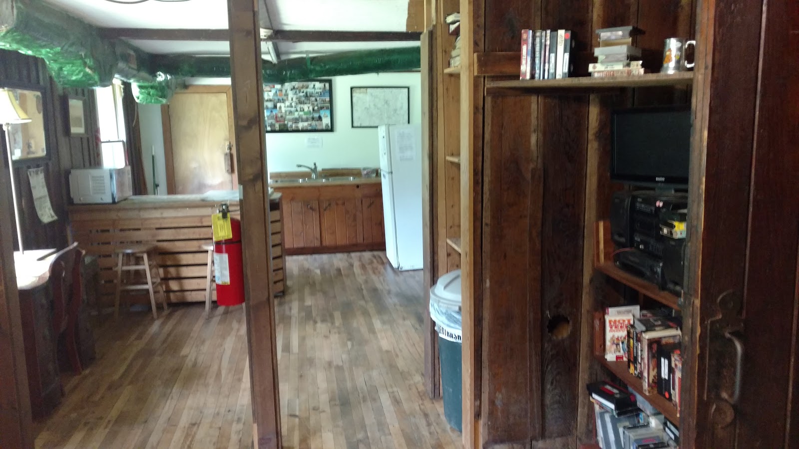
Sam, Sam, and Michael had planned to camp behind the center but around 4:30 a nasty thunderstorm rolled in and they conceded to the hostel with us. The hostel was very nice and clean, it included several bunk beds, a kitchen area, hot showers, and a main living space with an odd supply of VHS movies to watch. We watched the first part of Star Wars Episode I that evening.
It really was the perfect trail day and great rest for our legs and minds. The best part of the day was spending it with our new trail friends!
 |
| Unpacking and resupplying (photo courtesy of Michael) |
 |
| Sam's new tent in the hostel (completely normal hiker activity) |
 |
| Sam, Sam, & Michael (true trail friends!) |
 |
| Sam, Sam, and Cael play a game of cards |
 |
| Bunk for the night |
 |
| Hostel |
 |
| Patio at the hostel on a beautiful afternoon |
 |
| Cael looks on at our laundry drying |
 |
| Barq's root beer! |
 |
| Walasyi Center |
Day 5 - Neels Gap to Low Gap Shelter Mile 43.2 (July 6, 2017)
Mileage - 11.5 miles
Total Trip - 52.0 miles
We had a good night's sleep at the hostel on a real bed and both were up by 5:45 am. We packed up our gear making sure we hadn't left anything behind. My ultimate fear on the trip was leaving something critical behind like my water filter. Michael was up as he is a morning guy as well. We enjoyed our pop-tarts and saying goodbye to him. His AT journey had ended and had a shuttle picking him up that morning to return him to his car at Amicalola Falls. He took our picture under the arch and we were on our way out of Neels Gap. It was a humid morning and the climb out of the gap is long to Levelland Mountain. After descending Levelland it is another climb to Wolf Laurel where we stopped for our breakfast bagel topped with Nutella. My pack was once again filled after our resupply at Neels Gap. Anne had made us a large bag of trail mix which we tried to devour most of at the hostel, but I still was carrying some which we munched on along the way.
 |
| The AT crosses through Walasyi Center at Neels Gap, note the white blaze |
 |
| Wolf Laurel |
 |
| View from Wolf Laurel as the clouds break up |
 |
| Keep on Path |
As we descended off Wolf Laurel and started the climb of Cowrock Mountain the skies began to clear and we would be treated with the best views of our trip. Cowrock has several rock lookouts where the trees don't grow and offer a hard to come by view in Georgia. We met an older couple camped out on top of Cowrock as they made breakfast, it was the first hikers we had seen since leaving the hostel. They had climbed Cowrock in the storm last night and all their gear was soaked. We talked with them and they took our picture. We found lots of fresh blackberries which we enjoyed along with the view.
 |
| View from Cowrock Mountain |
 |
| Blackberries and a view |
 |
| Enjoying the view and sunshine |
 |
| Follow the white blazes, the peaks ahead we would climb later that day. |
We descended Cowrock with a boost of energy from the blackberries and views. It was a cooler day and the sun helped lower the humidity. We took a snack break at Tesnatee Gap and then it was two short but steep climbs up Wildcat Mountain. As we got to the top of Wildcat we had a little view back to Cowrock and the other climbs since Neels Gap. Cael was really amazed we had just come over those peaks and I think it sunk in at that moment just how big of a feat this trip is for an 8 year old.
 |
| Cael looking back to Cowrock Mountain |
We cruised into Hogpen Gap and from there it was an easy and quick 5 miles to the shelter. We took a water break at Sheep Rock Top and I had a phone signal. We called Anne and confirmed plans for pickup the next day at Unicoi Gap. I also pulled up the weather and saw a storm was approaching our area. We picked up the pace and cruised on down the mountain to Low Gap Shelter. Upon arriving we met a nice middle school teacher from Athens, GA out on a several day section hike. He is 50 years old and had previously section hiked the GA portion. He loves the area and also teaches an AT hiking gear course at the Len Foote Hike Inn when he has a chance. It was a pleasure to talk gear with him. He makes alot of his own items including his stove from a couple of pop cans.
 |
| Hogpen Gap |
 |
| Back to the woods from Hogpen Gap. |
By 3:30 pm we started to hear more thunder and the skies were getting dark. A couple small rain showers came by but at 4:30 pm the skies opened up with a lightning storm just above us. Thunder storms in the mountains are a whole different ball game than at your home. They literally shake the ground beneath the shelter and go through your body. We immediately began to worry about Sam and Sam who had planned to meet us at Low Gap Shelter that evening. We knew they would be still 1,000' up the mountain. We hoped they had been able to take some shelter with their tarp. Not long after the heavy rain started they came flying into camp! They were relieved to be there and us to see them.
 |
| Blue Blaze and sign for Low Gap Shelter |
We all congregated in the shelter and made our dinners. Cael and I had Alpine Aire chili which was delicious, Cael put his on tortilla shells and had 4 burritos, his hiker hunger had kicked in. We enjoyed our last evening on the AT trip in the shelter talking with Sam and Sam. We would be sad to say goodbye to them tomorrow and hope we see them again in the future. We all slept well with full bellies and light rain on the shelter roof.
Day 6 - Low Gap Shelter to Unicoi Gap Mile 52.9 (July 7, 2017)
Mileage - 9.7 miles
Total Trip - 61.7 miles
Last day on the AT of this trip! We woke up just after 5:30 am to a coyote call and then an owl, wilderness alarm clock! We packed up our gear one last time and waited for enough daylight to hike out. Sam and Sam were not far behind us that morning. The first half of the day would be a very nice easy hike with gradual long uphill and downhill sections. We cruised past the first 5 miles to Chattahoochee Gap in less than 2-1/2 hours. It was foggy but with a nice heavy breeze and temps near 70. The only excitement came when we startled a large animal on a slope below us, we both think it was a bear with the heavy pounding it made on the ground. Deer may be noisy running off but you can't hear their footsteps.
The climb to Blue Mountain (4021') was not a difficult up, but is very rocky. We slowly bouldered up taking a break to filter water just south of Blue Mountain Shelter. We met lots of hikers coming from Blue Mountain Shelter and then day hikers on the other side of Blue Mountain coming from Unicoi Gap. On top of Blue Mountain we met a Dad and his two sons (ages 12 and 14) who had cruised past us earlier in the week near Sassafras Mountain. They were slack-packing but putting up huge miles on daily sections. They were on a thru hike this summer of the whole AT!! They had started just north of the Smokies and were up in Massachusetts currently. They were unfortunately back in Georgia for a family funeral but were day hiking sections. What an experience for that family! Shortly after leaving them Cael discussed his plans to thru hike the AT one day! I hope he never loses his sense of adventure and confidence because if he puts his mind to it, it is already completed.
 |
| Top of Blue Mountain, last climb! |
 |
| Old fallen tree |
 |
| One of the last white blazes of our trip |
We quickly made the 1.1 mile hike down over 1,100' to Unicoi Gap and crossed Hwy 17 to the parking lot. We quickly took off our hiking shoes and made coffee and hot chocolate. It was 11:30 am and after calling Anne they would be there about 2:30 pm. We made great time and were early but could enjoy the rest. While taking our break we met a hiker who had thru-hiked the AT twice, once NOBO (Northbound) and once SOBO (Southbound). He had just gone on a day hike and was headed home. He talked alot about the GA section and the issues facing the AT currently due to increased use. He said over 5,000 people left Springer Mountain this spring as NOBO thru hikers (statistics show less than 25% will finish and only 75% make it past Neels Gap).
Shortly after Sam and Sam came by and then Anne drove up. Unfortunately Hazel had gotten car sick on the 8 mile drive up the mountain and threw up in her car seat. Anne cleaned Hazel up as we said our goodbyes to Sam and Sam.
 |
| Bama Sam, Michigan Sam, Cael, and I at Unicoi Gap |
 |
| We made it to Unicoi Gap!! |
 |
| More blackberries on the edge of the parking lot. |
The
Georgia Appalachian Trail Club manages the GA section may start charging to hike this section. The Appalachian Trail is an amazing asset to us and I am in favor of whatever is needed to keep it conserved and maintained. Our week long hike cost us nothing other than the food and gear we brought but we don't hesitate to buy a $50 ticket to a sports event. There are also many ways to support the
Appalachian Trail Conservancy by becoming a member, making a donation, or even getting their VISA card which donates a percentage of your purchases to the ATC. Please also make sure if you plan to go day hike or section hike any of our wonderful trails that you follow Leave No Trace Principles that I discussed in an
earlier post.
Cael and I learned alot about each other and hiking on this trip. We made a great set of memories and his confidence grew with each peak climbed. Here is a list of our biggest lessons from the trail:
Cael
- Bring enough food and know your next water source.
- A multi tool is worth the weight.
- Don't mess with copperheads.
- Don't leave anything behind
Andrew
- Trail friends are the best friends
- Cold mountain spring water is the best water you will ever have.
- Be flexible with daily mileage, its not the destination but the journey.
- Be completely honest with yourself and others, there is no room for ego on the trail, we are all out there learning and the best advice comes from those who have done it before.
- Sleeping in shelters is not that bad, setup is easy, protects you from the rain, creates a social event, and makes getting out of camp easy in the mornings.
- Expect to turn your phone off, I only had cell reception on a few peaks.
- Day-hikers think you are Superman but know you smell like Oscar the Grouch.
- The trail is an amazing education from wildlife to history.
- Cut pack weight wherever you can, every extra pound you will feel at mile 13 on a big climb.
- Take your kids with! This hike was perfect for Cael at age 8 but younger kids or those less excited about hiking will still benefit from shorter overnighters.
Final Thought:
Everyone hikes for a different reason. Sam from Michigan was hiking in memory of her brother Cody who had committed suicide two years earlier. Cody was a member of the military and was very talented serving on several special operation teams. Sam and Cody had planned to section hike the AT but never got the chance. She hiked with much of his gear and his story. We thank Cody for his service to this country and remember him. Sam planned to hike to Fontana Dam in North Carolina on this trip and then the Smokies with her Mom next summer. We can't wait to hear how her hike went.
 |
| My best bud and me! |
 |
| Hiking Itineary July 2017 |


Comments
Post a Comment